Back نهر زستشوپاو ARZ Zschopau (suba) CEB Zschopau (řeka) Czech Zschopau (Fluss) German Sapawa (rěka) DSB Zschopau (rivière) French Sapawa (rěka) HSB Чопау (река) Macedonian Zschopau NN Zschopau (rzeka) Polish
| Zschopau | |
|---|---|
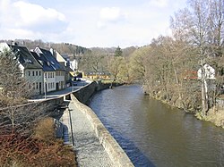
 The river in the town of Zschopau | |
| Location | |
| Country | Germany |
| State | Saxony |
| Physical characteristics | |
| Source | |
| • location | Fichtelberg, Ore Mountains |
| • elevation | 1,125 m (3,691 ft) |
| Mouth | |
• location | Freiberger Mulde |
• coordinates | 51°7′46″N 13°3′7″E / 51.12944°N 13.05194°E |
| Length | 128 km (80 mi) |
| Basin size | 1,750 km2 (680 sq mi) |
| Basin features | |
| Progression | Freiberger Mulde→ Mulde→ Elbe→ North Sea |
The Zschopau (German pronunciation: [ˈt͡ʃoːpaʊ̯], Czech: Sapava [ˈsapava] or Šopava [ˈʃopava]) is a 130-kilometre-long river in Saxony, Germany, and a left tributary of the Freiberger Mulde. The origin of the name is not precisely documented, possibly Slavic skapp; rock, cliff or sorb. Šučici; the rushing, roaring). The Zschopau drains a catchment area of 1847 km².